Eliminate the risk of costly utility strikes
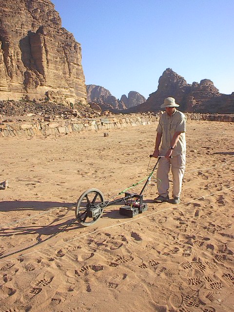
Whether you are core-drilling a commercial slab in Solon, installing a pool in Chardon, or prepping a fleet for EV charging stations in Cleveland, what you don't see can cost you thousands. Our utility locating services combine high-resolution GPR with field marking so crews see a clearer picture of underground utilities before you break ground — complementary to a required 811 ticket when public locates apply.
Guides: GPR & OHIO811 Deliverables after a locate All Learn articles
Our specialized services
-
Concrete scanning & structural mapping
Rebar, post-tension cables, and embedded conduits for safe core-drilling, sawing, and anchoring. Concrete scanning details →
-
Private utility locating
811 covers notified public facilities; private utility locating addresses laterals, campus loops, and yard lines. Gas, electric, fiber, and water on private property — GPR utility locating for what maps rarely show. Private utility locating details →
-
EV infrastructure site-prep
Trench pathing and slab context for fleet depots and high-voltage charger installs. EV site-prep details →
-
Residential: septic, wells & buried tanks
GPR for septic tank & leach field locating, private well lines, and buried heating oil tank locating — same insured reporting as our utility work.
-
Digital deliverables
Professional, date-stamped PDF reports with GPS-tagged locations for project records and insurance compliance.
"We don't just mark the ground; we provide subsurface intelligence."
— Carter, founder & principal
Standards & further reading
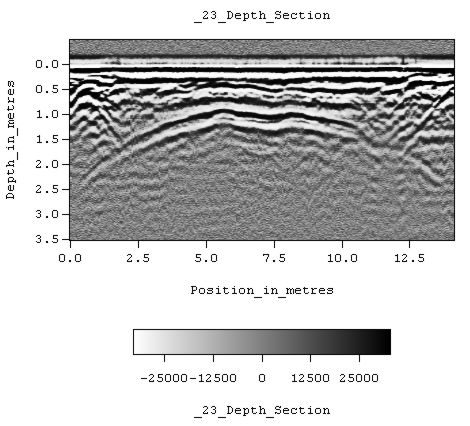
GPR results are interpretive: soil moisture, mineralogy, clutter, and target contrast change what we can defend in the field. We align field practice with commonly cited guidance such as ASTM D6432 (guide for GPR in subsurface investigation) and Ohio safe-dig practice coordinated through OHIO811 when public utilities are notified.
Nothing on this page replaces your engineer-of-record, environmental professional, or utility locator of record where regulations or contracts require them. Marks and reports document what the data reasonably supports under the stated site conditions.
Planning your scan
These details help us choose equipment, estimate time on site, and quote accurately — often before we mobilize.
-
1
Surface material
Concrete, asphalt, lawn, wet clay, or dry soil — soil and pavement type affects which antenna frequency we run.
-
2
Target depth
Typical buried utilities sit roughly 3–5 feet; septic tanks, larger structures, or legacy lines may require deeper imaging — tell us what you are trying to verify.
-
3
Deliverable
Field paint or flags only, a GPS-tagged PDF report for records, or both — we align deliverables to your GC package or homeowner closing checklist.
Pricing transparency
Base starting rates for common GPR work. Every site is different — share surface type, depth, and deliverables in your quote request for a firm, project-to-completion number.
| Service category | Starting price | What's included |
|---|---|---|
| Residential / small prep | $450 | Single-lot scan (up to 2 hours), private line marking, basic PDF summary. |
| Concrete & structural | $175 / hr | Rebar and conduit imaging before coring. A 2-hour minimum is typically recommended. |
| Commercial / EV site-prep | $1,200 / day | Full-day mapping, trench pathing, comprehensive 3D data report. |
Final project costs may vary based on site complexity and reporting requirements. Contact us for a firm project-to-completion quote.
Note: Sites beyond roughly 30 miles of Chardon include a $150–$300 mobilization charge for fuel and travel time.
Price + protection
Our $450 residential scan is backed by $1M professional liability (E&O) alongside general liability — documentation you can stand behind, not just paint on the ground.
Why work with us
Technical expertise
High-voltage systems and field service background — we understand what subsurface mistakes cost on energized sites.
Weekend & after-hours
Evening and weekend scans so your schedule stays on track for Monday pours and installs.
Local focus
Geauga, Lake, and Cuyahoga Counties — responsive mobilization without national-scale fees.
Insurance & liability
Many informal locators carry no E&O for professional mapping. We carry coverage suited to high-consequence subsurface work.
-
$1,000,000 general liability
Third-party property damage and site incidents.
-
$1,000,000 E&O / professional liability
Professional mapping errors — technical results backed by financial protection for your business.
-
CSDA GPR Certified & accredited
Principal holds Concrete Sawing & Drilling Association (CSDA) GPR certification; Arcbound Logic LLC is an accredited Ohio practice.
Ready to scan?
Book after 5 PM weekdays or weekends on our services hub, or send a detailed quote request.